
Smith Rock State Park
The Rundown
Spoon Rating:
2
Distance:
not listed
Elevation Change:
20 ft.
Typical Surface:
varied
Typical Width:
varied
Nearest Town:
Bend, OR
Cell Phone Reception:
varied
Amenities:
unlisted
Why go?
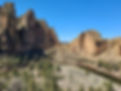
Smith Rock State Park, located near Bend, Oregon is described as one of the Seven Wonders of Oregon, and rightly so – it is a stunning place with incredible vistas. It is one of the most heavily visited places in Oregon, hosting rock climbers, equestrians, hikers, and other outdoor enthusiasts. Unfortunately, Smith Rock State Park does not rate well for accessibility and options are limited for disabled people traveling to the park. Oregon State Parks is working on improving trails and facilities, but currently there are no ADA compliant trails or viewpoints. There are three ADA-compliant tent campsites
The Hike
I visited Smith Rock State Park on a windy mid-week spring morning, and I would say the park was at about ½ capacity based on the number of available parking spots. I wandered around slowly without too much crowding or trail user conflict, but it would have been much more difficult if the park was busier – the trails are narrow, and stepping off the trail is rightly discouraged to protect the sensitive habitat. The viewpoints from the parking level are generally narrow as well and either located right along the trail with a barrier or off the trail along the cliff with a steep drop off.
I was disappointed that I could only visit the rim. I wanted to go down to the canyon, but the paved trail is very steep – I could only walk down a few feet before I felt unsafe, so I didn’t even get to take an accurate measurement of the grade. According to AllTrails, it drops 200 feet in under 0.2 mile, with a max grade of 40%. But if you can make down, there are several trail options that are fairly level.
There are two level trails at the rim: the North Point loop and the Rim Rock Trail. Both offer incredible views of the surrounding rocks and down into the canyon, but they each present their own accessibility challenges.

The beginning of the North Point Trail with a sign for the Homestead Trail on the right. Gravel trail surrounded by tall sage and small juniper trees with rocks rising in the background.
North Point Loop: One-spoon difficulty. 0.5 mile, no elevation change, loose large gravel surface, steep edges. The trail starts at the turnaround parking area at the end of the road into the park, near two accessible parking spots. It travels through sage and juniper along the north point of the rim, leading out to incredible views of the river gorge and surrounding rocks. Be very careful as you approach the edge of the rim – the basalt rock columns are not connected, there are many gaps, and no barriers with a very steep drop off. If you experience vertigo or have problems with balance, you may want to stay well back from the edge. I enjoyed taking in the silence punctuated by the sounds of geese and the buzz and flash of hummingbirds.
The trail loops to the right, and there is one bench in the shade with views out towards the opposite ridge. The trail is well defined and edged with rocks; it is approximately 3 feet wide and the surface is loose gravel rocks, occasionally a couple of inches deep. Wheel-users could have difficulty traveling on the loose, uneven surface. The loop ends back at the parking area between two standard parking spots with no defined exit space, so you may need to squeeze between cars.
The North Point amphitheater is to the left of the loop trail. This is a paved path, but the surface is uneven and cracked and you can’t see much above the rock wall. There is a viewpoint at the western edge of the Turnaround Parking lot with 15-minute parallel parking. There are nice views looking back across the park, and the wooden barrier does not block the views from sitting height.

Paved trail leading down to the canyon.

Bench in the shade on the North Point Trail overlooking the ridge.
Rim Rock Trail: Two-spoon difficulty. 0.5 mile point-to-point, no elevation change, loose pea gravel and boardwalk surface. You can begin this trail from behind the welcome center, the RV parking lot, or the Bivouac parking lot. The Rim Rock Trail follows the rim of the canyon, with views down to the river and across to the climbing rocks. I began from the RV lot, traveling left down a slight grade of 2-5% before curving sharply left at the first viewpoint. There are a few benches placed along the trail, with wooden barriers that partially block the view from sitting height. While it was interesting to watch the rock climbers, I personally enjoyed the many raptors soaring above the canyon and around their nests. The rocks are incredibly striking and there are views all the way out to the Cascade mountains.
The trail continues to curve left beyond the first viewpoint, and here there are a couple of steeper grades on loose pea gravel – I wasn’t able to measure, but I estimate they are around 10%, up to 20 feet long. You then cross a bridge with a step down on the opposite side, take a switchback with another steep grade, and cross a boardwalk with a two inch rise. The trail is generally three feet wide with loose pea gravel surface.

Viewpoint along the Rim Rock Trail.
Overall, I am glad I visited Smith Rock State Park, even if I wasn’t able to enjoy as much of it as I hoped. The views are astounding, and it felt very peaceful. The sun and wind felt wonderful on that spring day, but be aware there is very little shade anywhere in the park (with the exception of a shaded picnic area near the welcome center) and temperatures can rise to 100 degrees in the summer. I am sure I would have been more frustrated if I visited on a busy day; I recommend going early during the week if you can.
Hopefully the park will continue efforts to improve accessibility. It would be nice if there was some kind of shuttle service for disabled folks down to the canyon, if an exception can be made to the motorized use rule that would open up many more options for people who can’t navigate the steep climb. I hope to return to do a full assessment of the park and trails.
Finding the Trailhead
Pass/Entry Fee:
State Parks Pass/Entrance Fee
Getting There:
The park is easy to find using GPS. From Hwy 97 in Terrebonne, head east on Smith Rock Way. Turn left on 1st St, left on Crooked River Dr, and follow that into the park. There are three main parking areas, an overflow area, and vertical and parallel parking along the road in the park. Accessible parking is limited. Restrooms with accessible stalls are available. Cell signal is decent.
Nearby Alternatives:
Coming Soon
Land
Acknowledgement:
this is the traditional lands of the Northern Paiute and Warm Springs people, who hold extensive legends about the place now known as Smith Rock.